 |
||
|
|
Section Narbonne-Perthus of the Via Domitia

I have travelled the full length of the roman road where possible with my motorcycle in 2005. These visits comprise many roads and rural pathes where the roman road is still in use today as well as some offroad sections where the roman road was located with good maps and GPS. This placemark file is a collection of my GPS routes and tracks, which indicate those sections which I consider to be identified as parts of the 2000-years-old road. Even though I consulted plenty of literature I pass this information to you without warranty. Simply go there and see for yourself!
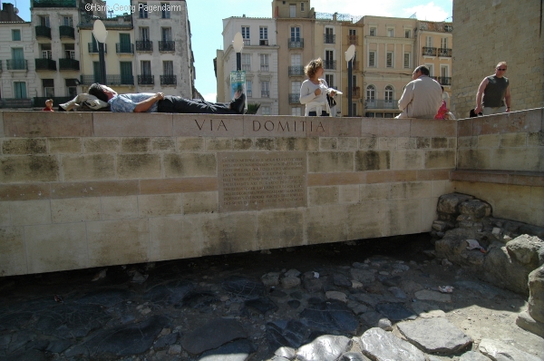 |
NarbonneA paved piece of the Via Domitia is displayed in the center of Narbonne in front of the palast of the archbishop. The road crossed what used to be the river Aude during the roman era on a living bridge still today covered with houses on both sides.
|
 |
Section: Narbonne-PerthusIn order to continue towards Spain the road led further west along today's N113 and D613 to the location of the Abbey of Fontfroide. From there the trach turn south towards Portel-des-Corbieres where the Voie Heracleenne is indicated on the map IGN. The path via Roquefort to the Chapel St.Pancrace near Lapalme is unclear to me. There are traces of a roman bridge at Treilles. Probably between Caves and Treilles there was a roman stop named Vincesinum. There is a milestone on display near Fitou along the N9. Traces of the road carved into the rocks may be visited near Malpas.The Via Domitia continued south to Salsuae (Salses le Chateau). A milestone from there was displaced to the church of St. Hippolyte. Almost straight south, only slightly east the obviously linear track continues. It passes Mas Guiter, the roman station Combusta and hits Claira. Bompas is passed on the east on the Chemin du Charlemagne crossing the Tet near Ruscino (Chateau Roussilon). There exist a Cami de Carlmany at Theza and north of Elne, however, the roman road probably passed Alenya in order to then turn straight to Illiberis which is today's Elne. South of Elne there was a station named Stabulum. The roman road the turned west up the river Tech which was crossed near Moulin du Broilla to join today's N9 near Le Boulou (Ad Centuriones). There was a roman fortresse Clausurae (near Les Cluzes) to protect the border to the spanish province. After crossing the Pyrenees near Les Perthus at the Col de Panissas the route continued as Via Augusta.
|
| more Google Earth related files | |
| Diese Seite auf deutsch |